Earth:Katian
| Katian | |
|---|---|
| 453.0 ± 0.7 – 445.2 ± 1.4 Ma | |
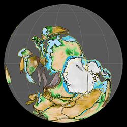
 Paleogeography of the Katian, 450 Ma | |
| Chronology | |
| Etymology | |
| Name formality | Formal |
| Usage information | |
| Celestial body | Earth |
| Regional usage | Global (ICS) |
| Time scale(s) used | ICS Time Scale |
| Definition | |
| Chronological unit | Age |
| Stratigraphic unit | Stage |
| Time span formality | Formal |
| Lower boundary definition | FAD of the graptolite Diplacanthograptus caudatus |
| Lower boundary GSSP | Black Knob Ridge section, Oklahoma, United States [ ⚑ ] 34°25′50″N 96°04′29″W / 34.4305°N 96.0746°W |
| GSSP ratified | 2006[1] |
| Upper boundary definition | FAD of the graptoliteNormalograptus extraordinarius |
| Upper boundary GSSP | Wangjiawan section, Wangjiawan, Yichang, China [ ⚑ ] 30°59′03″N 111°25′11″E / 30.9841°N 111.4197°E |
| GSSP ratified | 2006[2] |
The Katian is the second stage of the Upper Ordovician. It is preceded by the Sandbian and succeeded by the Hirnantian Stage. The Katian began 453 million years ago and lasted for about 7.8 million years until the beginning of the Hirnantian 445.2 million years ago.[3] During the Katian the climate cooled which started the Late Ordovician glaciation.
Naming
The name Katian is derived from Katy Lake (Atoka County, Oklahoma, United States).[4]
GSSP
The GSSP of the Katian Stage is the Black Knob Ridge Section in southeastern Oklahoma (United States). It is an outcrop of the Womble Shale and the Bigfork Chert, the latter containing the lower boundary of the Katian. The lower boundary is defined as the first appearance datum of the graptolite species Diplacanthograptus caudatus. This horizon is 4.0 m above the base of the Bigfork Chert.[5][6]
References
- ↑ Goldman, Daniel; Leslie, Stephen; Nõlvak, Jaak; Young, Seth; Bergström, Stig; Huff, Warren (December 2007). "The Global Stratotype Section and Point (GSSP) for the base of the Katian Stage of the Upper Ordovician Series at Black Knob Ridge, Southeastern Oklahoma, USA". Episodes 30 (4): 258–270. doi:10.18814/epiiugs/2007/v30i4/002. https://www.researchgate.net/publication/279565833. Retrieved 13 December 2020.
- ↑ Chen, Xu; Rong, Jiayu; Fan, Junxuan; Zhan, Renbin; Mitchell, Charles; Harper, David; Melchin, Michael; Peng, Ping'an et al. (September 2006). "The Global Boundary Stratotype Section and Point (GSSP) for the base of the Hirnantian Stage (the uppermost of the Ordovician System)". Episodes 29 (3): 183–195. doi:10.18814/epiiugs/2006/v29i3/004. https://www.researchgate.net/publication/262923312.
- ↑ "GSSP Table - Paleozoic Era". Geologic Timescale Foundation. https://engineering.purdue.edu/Stratigraphy/gssp/index.php?parentid=77.
- ↑ Bergström, Stig; Finney, Stanley; Xu, Chen; Goldman, Daniel; Leslie, Stephen (31 August 2006). "Three new Ordovician global stage names". Lethaia 39 (3): 287–288. doi:10.1080/00241160600847439.
- ↑ Goldman, Daniel; Stephen A. Leslie; Jaak Nõlvak; Seth Young; Stig M. Bergström; Warren D. Huff (2007). "The Global Stratotype Section and Point (GSSP) for the base of the Katian Stage of the Upper Ordovician Series at Black Knob Ridge, Southeastern Oklahoma, USA". Episodes 30 (4): 258–270. doi:10.18814/epiiugs/2007/v30i4/002. http://www.stratigraphy.org/GSSP/file37.pdf. Retrieved 20 September 2012.
- ↑ "GSSP for Katian Stage". Geologic Timescale Foundation. https://engineering.purdue.edu/Stratigraphy/gssp/detail.php?periodid=134&top_parentid=77.
[ ⚑ ] 34°25′50″N 96°04′29″W / 34.4305°N 96.0746°W
 |

