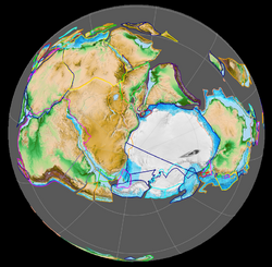
Earth:Pridoli epoch
From HandWiki
Revision as of 18:44, 14 July 2022 by imported>Jport (update)
Short description: Final Series (Epoch) of the Silurian
| Přídolí | |
|---|---|
| 423.0 ± 2.3 – 419.2 ± 3.2 Ma | |
 Paleogeography of the Pridoli, 420 Ma | |
| Chronology | |
| Etymology | |
| Name formality | Formal |
| Name ratified | 1984 |
| Usage information | |
| Celestial body | Earth |
| Regional usage | Global (ICS) |
| Time scale(s) used | ICS Time Scale |
| Definition | |
| Chronological unit | Epoch |
| Stratigraphic unit | Series |
| Time span formality | Formal |
| Lower boundary definition | FAD of the graptolite Monograptus parultimus |
| Lower boundary GSSP | Požáry Section, Řeporyje District, Prague, Czech Republic [ ⚑ ] 50°01′40″N 14°19′30″E / 50.0277°N 14.3249°E |
| GSSP ratified | 1984[4][5] |
| Upper boundary definition | FAD of the graptolite Monograptus uniformis |
| Upper boundary GSSP | Klonk, Prague, Czech Republic [ ⚑ ] 49°51′18″N 13°47′31″E / 49.8550°N 13.7920°E |
| GSSP ratified | 1972[6] |
In the geologic timescale, the Přídolí epoch is the uppermost subdivision of the Silurian period, dated at between 423 ± 2.3 and 419.2 ± 3.2 mya (million years ago). The Přídolí epoch succeeds the Ludfordian Stage and precedes the Lochkovian, the lowest of three stages within the Lower Devonian geological epoch. It is named after one locality at the Homolka a Přídolí nature reserve near the Prague suburb, Slivenec, in the Czech Republic.[7] The GSSP is located within the Požáry Formation, overlying the Kopanina Formation. Přídolí is the old name of a cadastral field area.[8]
Pridoli geology
Pridoli life
Arthropods
Vertebrates
Bony fish
| Bony fish of the Pridoli | ||||
|---|---|---|---|---|
| Taxa | Presence | Location | Description | Images |
| Andreolepis | ||||
| Guiyu | ||||
| Lophosteus | ||||
| Psarolepis | ||||
References
- ↑ Jeppsson, L.; Calner, M. (2007). "The Silurian Mulde Event and a scenario for secundo—secundo events". Earth and Environmental Science Transactions of the Royal Society of Edinburgh 93 (02): 135–154. doi:10.1017/S0263593300000377.
- ↑ Munnecke, A.; Samtleben, C.; Bickert, T. (2003). "The Ireviken Event in the lower Silurian of Gotland, Sweden-relation to similar Palaeozoic and Proterozoic events". Palaeogeography, Palaeoclimatology, Palaeoecology 195 (1): 99–124. doi:10.1016/S0031-0182(03)00304-3.
- ↑ "Chart/Time Scale". International Commission on Stratigraphy. http://www.stratigraphy.org/index.php/ics-chart-timescale.
- ↑ Lucas, Sepncer (6 November 2018). "The GSSP Method of Chronostratigraphy: A Critical Review". Frontiers in Earth Science 6: 191. doi:10.3389/feart.2018.00191. Bibcode: 2018FrEaS...6..191L.
- ↑ Holland, C. (June 1985). "Series and Stages of the Silurian System". Episodes 8 (2): 101–103. doi:10.18814/epiiugs/1985/v8i2/005. https://timescalefoundation.org/references/Silurian1.pdf. Retrieved 11 December 2020.
- ↑ Chlupáč, Ivo; Hladil, Jindrich (January 2000). "The global stratotype section and point of the Silurian-Devonian boundary". CFS Courier Forschungsinstitut Senckenberg. https://www.researchgate.net/publication/260135817. Retrieved 7 December 2020.
- ↑ Gradstein, Felix M.; Ogg, James G.; Smith, Alan G. (2004). A Geologic Time Scale 2004. ISBN 9780521786737.
- ↑ Manda, Štěpán; Frýda, Jiří (2010). "Silurian-Devonian boundary events and their influence on cephalopod evolution: evolutionary significance of cephalopod egg size during mass extinctions". Bulletin of Geosciences 85 (3): 513–40. doi:10.3140/bull.geosci.1174. http://www.geology.cz/bulletin/contents/art1174.


