Astronomy:Lucus Planum
From HandWiki
Short description: Region on Mars
 Topographic map showing the boundaries of Lucus Planum | |
| Feature type | Plateau |
|---|---|
| Location | Mare Tyrrhenum quadrangle, Mars |
| Coordinates | [ ⚑ ] : 4°59′S 177°10′W / 4.983°S 177.167°W[1] |
| Diameter | ~900 km[1] |
| Eponym | Latin lucus |
Lucus Planum is a region on Mars, named after an albedo feature. Its name was approved by the IAU in 1997.[1] The center latitude of the feature is 4.99 degrees S and the center longitude is 182.83 degrees.[1] It lies just to the east and north east of the volcano Apollinaris Patera. Lucus Planum lies in both the Memnonia quadrangle and the Aeolis quadrangles. It is part of a region called the "Medusae Fossae Formation"[2] Part of this region is covered with yardangs. They are formed by the action of wind on sand sized particles; hence they often point in the direction that the winds were blowing when they were formed.[3][4] Views of yardangs in this region are shown below.
-
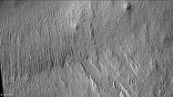
 Wide context view of surface of Lucus Planum, as seen with CTX.
 -
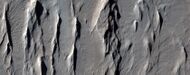
 Closer view of yardangs from previous image, as seen with CTX.
 -
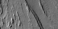
 Wide view of yardangs in Lucus Planum, as seen by HiRISE under HiWish program
 -
 Close view of yardangs in previous image, as seen by HiRISE under HiWish program
 -
 Close view of yardangs from a previous image, as seen by HiRISE under HiWish program


See also
References
- ↑ 1.0 1.1 1.2 1.3 "Lucus Planum". Gazetteer of Planetary Nomenclature. USGS Astrogeology Research Program. (Center Latitude: -4.99°, Center Longitude: 182.83°)
- ↑ Orosei, R. (2016). "Radar sounding of Lucus Planum, Mars, by MARSIS". Journal of Geophysical Research: Planets 122 (7): 1405–1418. doi:10.1002/2016JE005232.
- ↑ "'Yardangs' on Mars". http://www.esa.int/Our_Activities/Space_Science/Mars_Express/Yardangs_on_Mars.
- ↑ "HiRISE | on the Beauty of Yardangs (ESP_040504_1920)". http://www.uahirise.org/ESP_040504_1920.
 |  |
